- Home
- Trans-Alpine Crossing Munich Venice
- Lake Constance to Lake Königssee - Classic Tour
- Isar Cycle Route
- Munich - Lake Garda
- Allgäu Cycle Loop
- From Salzburg to Grado by E-bike
- The river Ammer-Amper cycling trail
- Munich Lakes West Tour Classic
- Kitzbühel - Three Peaks
- KAT-Walk
- Mystery moors, lakes and mountains
- From Lake Tegernsee to Kitzbühel
- Trans-Alpine Crossing from Tegernsee to Vipiteno
- SalzAlpenSteig I
- Bavarian Alps & Lakes
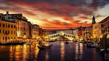
- From Lake Garda to Venice
- From Cortina to Venice
- Service
- About us
Royal cycling tour from lake Constance to lake Königssee: Classic
bike trip - Fire and Ice Own Tour
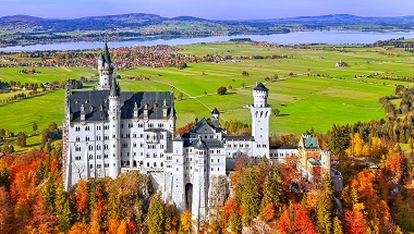
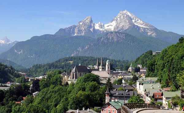
The Bodensee Königssee Cycle Route always follows the northern edge of the Bavarian Alps. The bike path crosses Allgäu/Bavarian Swabia and Upper Bavaria. Small villages alternate with traditional health resorts and spas. The starting point is Lindau, from where you will enter the hilly Allgäu region. After an unforgettable view of the Allgäu Alps, the Zugspitze and the Tannheim Mountains, you reach Hohenschwangau and catch sight of what is probably Germanys most famous postcard motif: Neuschwanstein Castle, built by King Ludwig II. In Benediktbeuern, the Benedictine monastery with its more than 1,250 years of history invites you to visit. The bike path reaches Bad Tölz on the Isar River and through the Upper Bavarian picture book landscape the route leads to Lake Tegernsee, Lake Schliersee and finally to Lake Chiemsee Via Traunstein the way leads to Bad Reichenhall and Berchtes... continegaden, in the midst of the alpine landscape of the Berchtesgaden National Park. Lake Königssee is a truly crowning finale to a royal cycling tour.
| 01. DAY |
| Arrival Individual Arrival at starting point Lindau |
02. DAY
|
| From Lindau to Oberstaufen From Lindau on Lake Constance, the route first leads along the Leiblach, which is also the border to Austria, and a little later up into the hilly Allgäu. Scattered farms and small villages between forests and pastures dominate the landscape. The first stage leads to Oberstaufen via Hergenweiler, Maria-Thann and Röthenbach. |
03. DAY
|
| From Oberstaufen - Füssen The second stage leads through the valley of the Konstanzer Ach to the Großer Alpsee and passed the Kleiner Alpsee to Immenstadt. Continue south along the Illerradweg to Sonsthofen, where you cross the Iller. Continue north again past the Agathazeller Moos, about 4km north of Sonthofen, to Rettenberg at the foot of the Grünten massif with the 1730m Übelhorn. From here, the tour continues uphill, past the Rottach reservoir, via Memersch (at 1000m above sea level, the highest point of the entire Lake Constance-Königsee cycle path), Oy-Mittelberg and Maria Rain to Nesselwang, at the foot of E... weiterlesendelsberg and Alpspitze. From Nesselwang, with a view of the Allgäu Alps, you cycle through forests and fields past small villages to Füssen. |
04. DAY
|
| From Füssen - (Region Blue Land) From Füssen, the route now passes Hohenschwangau and Neuschwanstein. In addition to the Forggensee and Bannwaldsee, seven large and numerous smaller lakes can be found here. Via Schwangau, the route then leads past the Bannwaldsee lake to Trauchgau. The route continues from Trauchgau along field paths and small side roads via the Wieskirche church and Wildsteig over into the Halbammer valley and down to Altenau. From here the route leads past the Altenauer Moor nature reserve via Saulgrub to Bad Kohlgrub. From Bad Kohlgrub, the route continues downhill to Grafenaschau and at the foot of the A... weiterlesenschau mountains - along the Murnau and Eschenloher Moos nature reserve. |
05. DAY
|
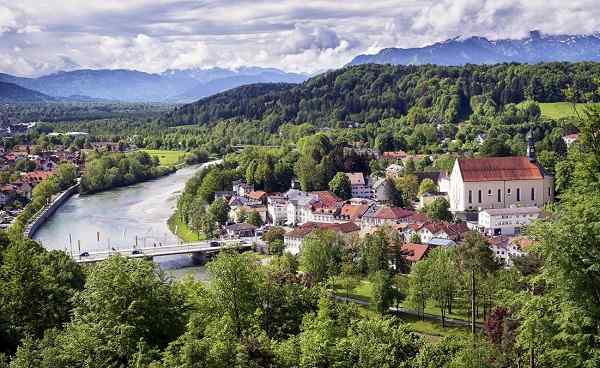
| From (Region Blue Land) - Bad Tölz The fourth stage leads from Eschenlohe along the Loisach river and past the Schwaiganger stud farm, the largest horse stud farm in Bavaria, to Kochel am See. Kochelsee lies at the foot of the 1731 m high Herzogstand, behind which the Walchensee, 200 m higher, is hidden. The route continues level, at the foot of the mountains, through the wet meadows of the Loisachmoore to Benediktbeuern with views of the Benediktenwand (1800m). Past Bad Heilbrunn, the route continues between Blomberg (1248m) and Stallauer Weiher to Bad Tölz on the Isar. |
06. DAY
|
| From Bad Tölz - Region Rosenheim The fifth stage leads from Bad Tölz along country lanes and side roads with gentle ups and downs to Greiling, Reichersbeuern and through Waakirchen. From here on to Gmund am Tegernsee and via Hausham and Schliersee to Fischbachau. The route continues around the Wendelstein (1838m) and the mountains in front of it, through forests and fields down to the Mangfall plain and the Rosenheim region. |
07. DAY
|
| From Region Rosenheim - Siegsdorf From here, the route continues slightly downhill through the Moos to Neubeuern / Altenmarkt am Inn. From Altenmarkt, the route goes slightly uphill via Rohrdorf and a little later along the A8 to Frasdorf. From here it is not far to Aschau im Chiemgau. The route leads slightly downhill to Bernau, at the foot of the Kampenwand (1668m) and at the south-western end of the Chiemsee. Without any major ascents, the stage then runs between the mountains Hochfelln at 1664m and Hochgern at 1633m and the moors off the Chiemsee via Grassau to the town of Bergen. Between Bergen and Siegsdorf there is anot... weiterlesenher small climb to overcome. |
08. DAY
|
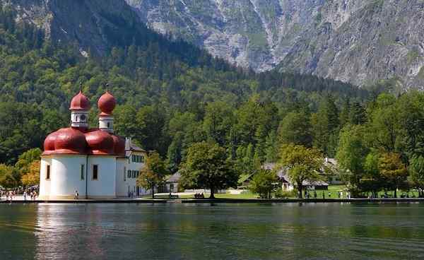
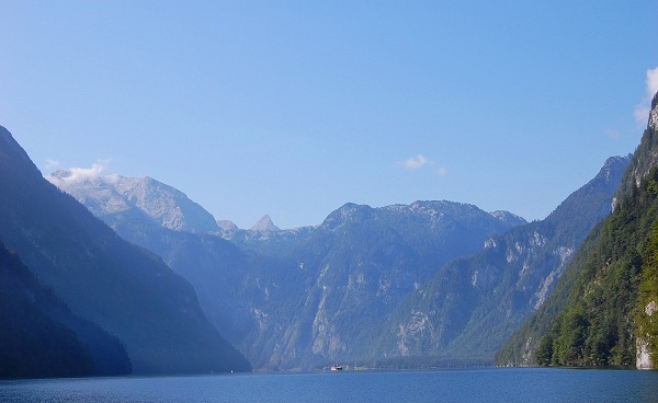
| From Siegsdorf - Brchtesgaden/Königssee The last stage leads from Siegsdorf along the Traun River to Traunstein. Then it goes up and down gently over the plateau and back down to Teisendorf, at the foot of the Teisenberg (1333m). The route then leads along the Ramsaubach without any major climbs past Höglwörther See and via Anger into the Rupertiwinkel to Piding, close to the Saalach and Bad Reichenhall. From Piding along the Saalach to Bad Reichenhall, situated at the foot of the Latent Mountains and the edge of the Untersberg National Park. From Bad Reichenhall the route then leads up to Bayerisch Gmain and in the narrow valley ... weiterlesenbetween Berchtesgadener Hochthron (1972m) and Predigtstuhl (1688m) to Berchtesgaden. From Berchtesgaden it is only a stones throw (approx. 30 min.) to the destination of the long-distance cycle route. Lake Königssee, located in the national park of the same name, is only about 6 kilometres from Berchtesgaden. Its up to you whether you cycle the last stretch today or take your souvenir photo at the world-famous Königssee the next morning. |
| 09. DAY |
| Departure Individual departure |
Booking code: BKR-STANDARD-M-GEPAECK-EN
| Season | Category | Single room | Double room p.P. |
| 01.07.2024 - 31.08.2024 (start day: Sat) | Standard | 1.499 EUR | 1.199 EUR |
| 01.09.2024 - 13.10.2024 (start day: Sat) | Standard | 1.479 EUR | 1.179 EUR |
All prices per person in EURO
Minimum number of participants: 4 persons per date
Minimum number of participants: 4 persons per date
Services Included
- done 8 nights in 3-4* Hotels or Inn´s
- done Daily breakfast
- done Accommodation including bathrooms with bath or shower
- done Daily luggage transfer between hotels
- done Digital travel documents per room
- done Oberstaufen PLUS Card (mandatory)
- done Handlebar bag for your travel documents (one per room)
- done GPS data is available for download
Services not included
- ×Arrival to and Departure from the tour
- ×Cycling Equipment as helmet, shoes etc.
- ×All local taxes
- ×Parking costs, or any other personal costs
- ×Boards, that are not mentioned as included services
- ×Transfers, that are not mentioned as included services
Other notes
To ensure a stress-free start to the trip, we recommend arriving at the starting point by early evening in most cases. Some tours start as early as midday, in which case we recommend arriving the day before and will be happy to book an extra night for you at the same time. The individual return journey takes place on the last day of the tour. The distances are approximate and may differ from the actual distances covered. This tour is not suitable for people with reduced mobility.
Tour character
Hilly terrain of the foothills of the Alps, partly natural paths. Partially larger inclines and declines, therefore suitable mainly for sporty cyclists.
Transfer
Return transfer Berchtesgaden-Lindau always bookable on Sundays for 230 EUR per person (price valid from 4 persons in the vehicle)
Parking
- Hartplatz Zech - Park Ride (unguarded, Bregenzer Straße 177) - 182 parking spaces in the Zech district of Lindau - 2,00 € per day - Recommended for stays of up to 14 days in order to avoid traffic congestion and long searches for parking spaces. - For reasons of immission control it is not allowed to drive in or out after 22:00 oclock until 06:00 oclock.
Minimum number of participants
If a minimum number of participants is required for the tour to take place, this is stated under "Prices and services". If the minimum number of participants is not reached, we reserve the right to cancel the trip up to four weeks before the "arrival date". We recommend organizing the arrival and departure only after this deadline has passed.
7-day carefree number
No matter how well planned a trip is, in rare cases unexpected things happen. At such times, it is nice to have someone you can rely on locally. For this reason, you have a local contact person on our individual activity trips who will be happy to provide you with information and, as stated in the travel documents, can be contacted in an emergency.